הרי ברוס
| הרי ברוס |
|---|
הרי ברוס (באנגלית: Bruce Mountains) הם רכס הרים על החוף הצפוני של האי באפין, בטריטוריית נונאווט שבקנדה.
רכס ההרים מהווה תת-רכס של הקורדילרה הארקטית. ההרים נמצאים דרומית מזרחית מפיורד דקסטריטי, וצפונית מערבית מפיורד קלארק[1].
ההרים מגיעים לגובה של 457 מטרים מעל פני הים[2]. שטח הרכס 4,597 קמ"ר[3].
הרכס הוא מוצאם של ארבעה קרחונים הזורמים אל מתחת לפני האוקיינוס הארקטי[4].
לקריאה נוספת
• Gifford H. Millera, Alexander P. Wolfea, Eric J. Steiga, Peter E. Sauera, Michael R. Kaplana, Jason P. Briner, The Goldilocks dilemma: big ice, little ice, or ‘‘just-right’’ ice in the Eastern Canadian Arctic, Quaternary Science Reviews 21 (2002), PP 33–48
• Harrison, D.A., A reconnaissance glacier and geomorphological survey of the Duart Lake Area, Bruce Mountains, Baffin Island, N.W.T. Geographical Bulletin 21, 1964, P 57–70
• J.A. Dowdeswell, M. Canals, M. Jakobsson, B.J. Todd, E.K. Dowdeswell, K. Hogan, Atlas of Submarine Glacial Landforms: Modern, Quaternary and Ancient, P 89
קישורים חיצוניים
הערות שוליים
- ↑ מיקום הרכס
- ↑ גובה הרי ברוס
- ↑ מידע גאוגרפי
- ↑ ראו ב"לקריאה נוספת": Atlas of Submarine Glacial Landforms
| הקורדילרה הארקטית | ||
|---|---|---|
| רכסי הרים | אדם • ארצות הברית • באפין • ברוס • ג'וי • גרינל • האימפריה הבריטית • הנסיכה מרגרט • הייפוינטר • ויסלר • ויקטוריה ואלברט • | 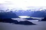 |
| הרים | אאוטלוק • אודין • אוקספורד • אנגנה • אסגרד • ארוהד • ארתור • באטל • בלדר • באסטיל • ברבאו • ברייב • ויסלר • יוג'ין • מידנייט סאן • סירק • | |
| מעברי הרים | פורטרס • | |
| כיפות קרח | פני • | |
| קרחונים | גל • | |
| פארקים לאומיים | סירמיליק • | |
| אזורים | באפין • | |

הערך באדיבות ויקיפדיה העברית, קרדיט,
רישיון cc-by-sa 3.0
רישיון cc-by-sa 3.0
This article is issued from Hamichlol. The text is licensed under Creative Commons - Attribution - Sharealike. Additional terms may apply for the media files.